• About
  • Who Are We?
  • The Cortland Fire of 1919
  • Textual Visualization
  • Augmented reality
  • Games!
    • Games Assignment
Digital Humanities – Spring 2018

Digital Humanities – Spring 2018

Central College Student Map-Sarah Feinman

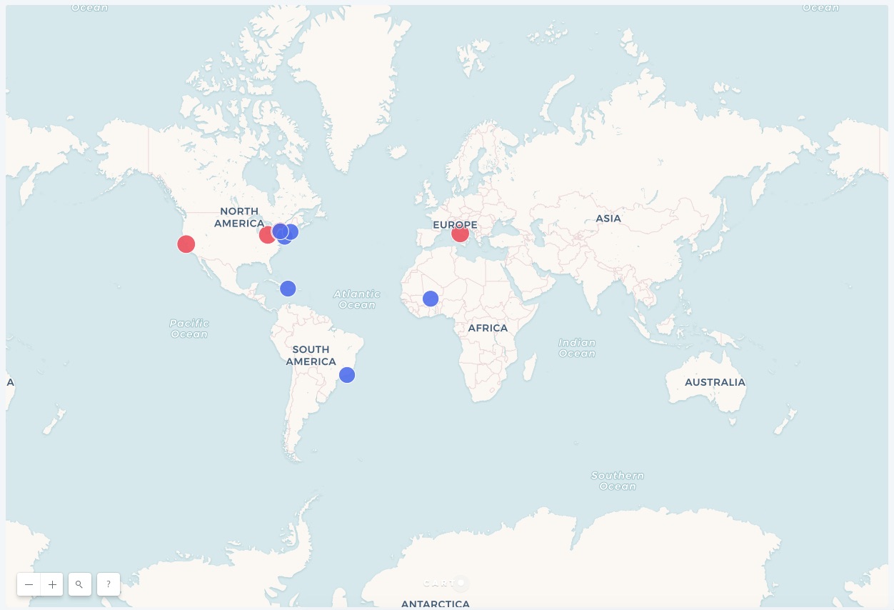
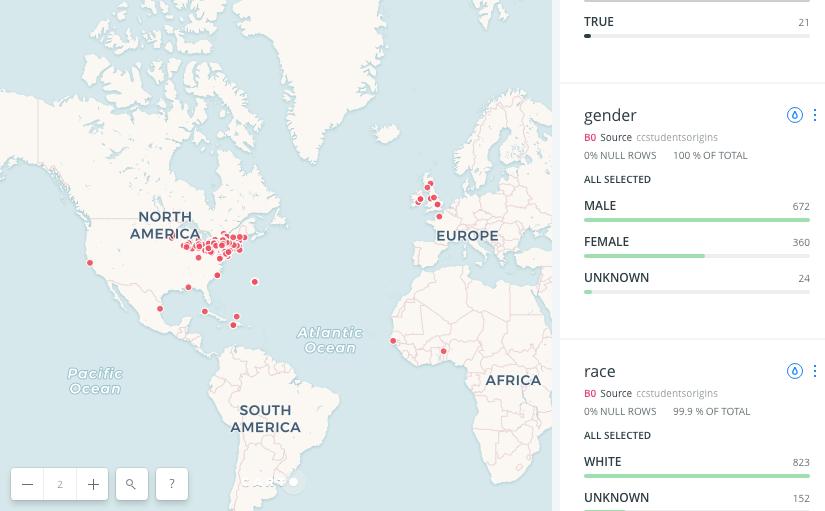
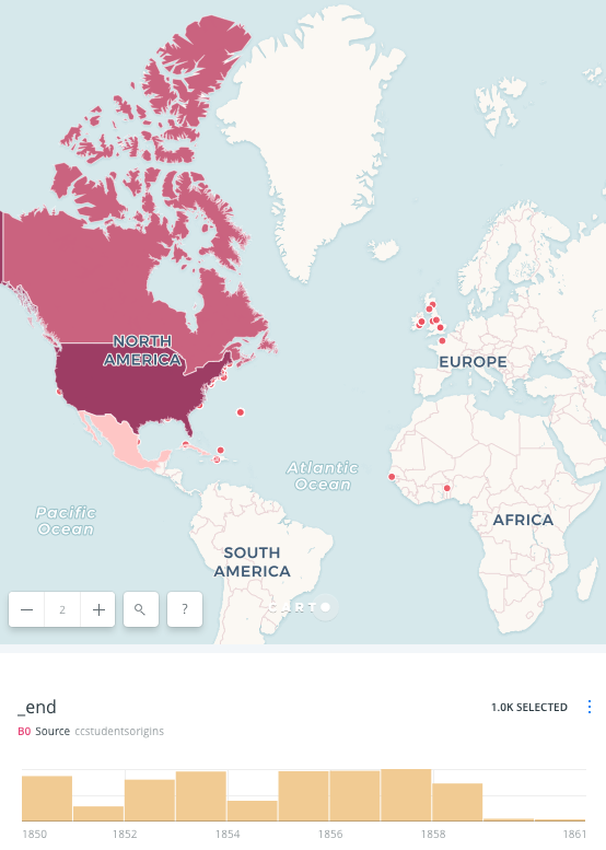
The first week of class consisted of mapping out different origins. Essentially, the goal of this assignment was to see an accurate visualization of the different places and locations of students who went to Central College in McGraw. Central college is known for appreciating diversity as a community, which is why I found this exercise very practical. Additionally, Central College was he first college to accept  woman and colored people. The great amount of diversity at this school created many interesting points on the map. Mapping is an extremely useful tool, and this assignment definitely clarified this.

For this assignment, everyone in the class received a group of 30 students. We then plugged in the coordinates of each students hometown to find their specific origins and locations. I was very surprised to see how far many students traveled to attend Central College. Traveling also wasn’t easily accessible during this time in history, which is why I found this concept very interesting.

Mapping is  an especially helpful tool to use when learning new historical information. Before this assignment, I was not aware of this tool. As a future teacher,  I am definitely interested in using mapping to create a beneficial learning atmosphere for my students. I believe this tool will be especially useful for the special education students in my classroom. Many students who identify with a disability tend to be visual learners, which is a main aspect of mapping. It definitely is more useful to see a visualization of the location instead of a standard list. I am excited to share this useful tool with my future students.


April 12, 2018

Group 1 Blog Post #2 Student Biographies

Ezekiel Johnson, Sarah Feinman and Garrett Sweeney

In our group we researched two different types of people that were connected through the New York Central College in McGrawville, New York. These people were Mary Lewis and Mahommah Baquaqua. Mary Lewis was an African American activist who was always fighting for her people of the same race during this time period around/during the civil war. She lived mainly in the United States apart from the portion of her life when she studied in Rome for a little while. She was very popular and newspapers all around the country had articles on her work and what she was doing to progress equality for African Americans and also honoring fallen African American soldiers in the civil war.

Baquaqua moved around the world a little more than Mary Lewis. Baquaqua started off born in his village in Zoogoo, West Africa which I believe is modern day Burkina Faso. He was then captured by Europeans for slavery and sent to Brazil. After he arrived he was bought by the captain of the ship who was heading for New York. This changed his life entirely. He arrived and eventually escaped with the help of abolitionists and moved to Boston. After this he eventually made it to McGrawville to attend the New York Central College where he and Mary Lewis were connected.

Here is a map of where the two have been to give a better picture of their travels. The red points are Mary Lewis and the blue points are Mahommah Baquaqua.

April 12, 2018

The Lost Museum

Zeke Johnson

The Lost Museum website offers interesting insights into digital exhibits and what they offer teachers and students alike. The introduction video creates an interest in visitors to the site, while the subsequent activity and virtual tour expand on that interest, and provide answers to the questions digital visitors may have. The tour was fascinating as it allows visitors to explore a physical space in the virtual world. This concept is a continuation of the topics we have been discussing all semester in Digital Humanities on the importance of digital spaces in the physical world. Augmented reality has been discussed as a possible teaching tool, and a virtual museum seems to fit right in with this concept, but at the same time kind of inverts it. By this I mean that a projection of a physical space onto the computer screen allows for a museum tour from the comfort of your own home.

This also has educational value especially here in the US. where schools can be some what underfunded. Instead of going on a field trip to an actual museum, classes could theoretically take a virtual tour instead, that way the school could save money, and who doesn’t like saving money. 

It is interesting to see the many places that have been lost to history, and the recreations of these places in a virtual space. It lends credence to the idea that history is never truly lost until collective memory has completely vanished, and the lost museum is a good example of how history can be preserved well after its physical components have vanished to the ages.

April 12, 2018

The Potential of Virtual Reality

I believe that the potential for Virtual reality for understanding the past is immeasurable. Virtual reality gives users the opportunity to be completely immersed in a new world, and would undoubtedly aid people in learning more about the past; rather than reading a textbook, watching a video, or listening to a lecture about history, websites such as The Lost Museum and The Chernobyl Project allow users to explore the past in a completely new way, as if they were a part of it. I believe that students and people in general find this method much more interesting, being able to explore new dimensions of events or places that they otherwise could not. These virtual reality programs are also extremely beneficial because they offer accessibility for anybody with access to the internet; you no longer have to travel to Japan to see the aftereffects of Nagasaki, and can see the streets of Chernobyl without risk of disease. Overall, I believe virtual reality is very useful and valuable to those who wish to learn more about history, and I am excited to see how it expands from here.

April 12, 2018

The Lost Museum

The Lost Museum presents a re-creation of P.T. Barnum’s American Museum as a way to view mid-19th century New York City and antebellum America. The website offers visitors a virtual museum where you can explore freely and act as if you are in Barnum’s American Museum. It is a 3-D re-creation of P.T. Barnum’s American Museum, that was mysteriously destroyed by fire on July 13, 1865. This concept is great because it allows people into the past in a way where it is interactive and engaging. Being able to use virtual reality or other graphic simulations makes for different perspectives to come about because you can view data or history in a different light that perhaps you might not have seen before. It can also lead to new questions which can lead to new research and new findings. Using this material that helps the average person appreciate history a lot more as you are more immersed in the material than rather than just reading it out of a book. This technology can help recreate ancient civilizations or what they might have looked like, in addition, the viewer can get a better sense of the time period for example, the lost museum offers visitors a chance to see mid-19th century New York City and antebellum America.


-JP Ospina

April 12, 2018

1st Carto Post–General Spatial Trends Group 1

Zeke Johnson, Sarah Feinman, Garrett Sweeney

For this assignment, our group was tasked with figuring out which students that went to Central college  were from outside the US. To do this was not as simple as filtering by column value, because the dataset did not inherently have a column for U.S. to Non/U.S. students. We ended up creating an overlay for the data that showed the data in terms of a colored map based on North American residency.

By organizing the data in this fashion, it is easy to see that in the second half of the college’s lifespan, more students came from abroad. The ratio of foreign born students to U.S. born students also increases after 1855.

By noticing this change over time, we can make a guess at the reasons the attendance would increase. Word about Central College probably spread as its students graduated and moved to other places. Originally two students came from Africa, and later on a handful hailed from Great Britain, and the Carribean.

Our other map lends a hand in the understanding of this phenomenon. We plotted the places that Mahommah Baquaqua, who was a student at Central College, lived in his life and found that he lived in Haiti for a time. This student’s time in Haiti could definitely have influenced the other students who came to Central College later in the 1850s.

Overall, while the ratio of students changed over time, the changes still only represented a small percentage of the overall Central College student body.

Here is our map that we used for this assignment.

April 12, 2018

  • « Previous Page
  • 1
  • …
  • 6
  • 7
  • 8
  • 9
  • 10
  • …
  • 26
  • Next Page »

SUNY Cortland